
Businesses change with the times, embracing technology and methods that make doing businesses easier, faster, and more accurate, and less expensive. The construction industry, however, is very set in its ways and tends to lag behind other industries in adopting these new technologies and reaping their benefits.
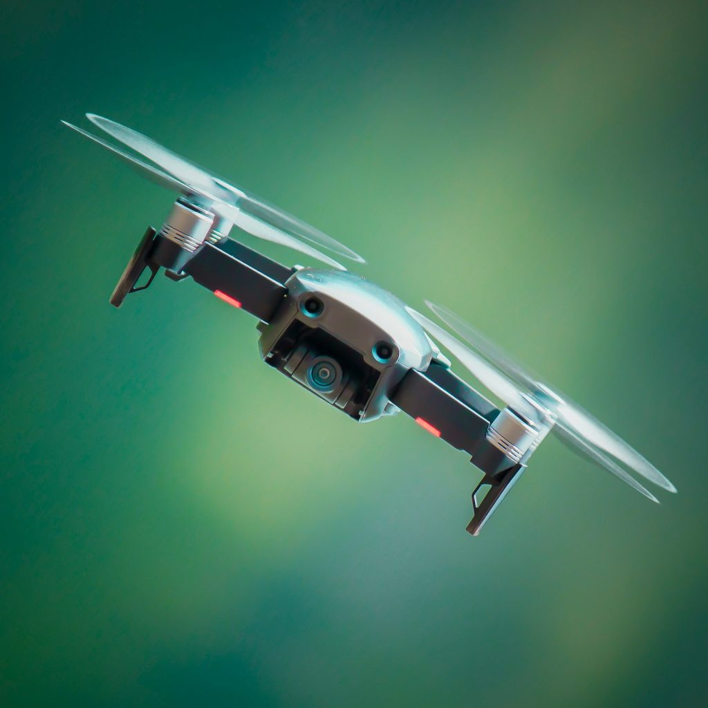
Some construction companies have turned toward software management systems which allow them to input data and come up with more detailed solutions faster than any human could compute the same data. Another big technological update for the industry to embrace is the use of drones to survey and monitor sites.
Table of Contents
Benefits of Drones in Construction
If your company wants to be on the cutting edge of technology in the construction industry, incorporating drone surveying and monitoring in your services is a great way to stay current. Taking the time to invest in a drone or drones has some major benefits for both company and clients.
Efficiency
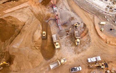
As it’s said: work smarter, not harder. There used to be only one way to survey a construction site, and it wasn’t easy. Time, money, a workforce with a specific skill set, and the potential of starting over if something goes wrong or changes. It’s a tedious process, with even the most experienced surveyors only being able to survey about 5 acres per hour. On a late spring day with over 15 hours of sunlight, that’s only 75 acres working continuously. Enter the drone, operated by one of the most beginner level surveyors. That pairing can survey up to 120 acres per hour. On a similar late spring day, that’s 1800 acres!
If you’re still using traditional surveying methods, a large construction site may require multiple work days to complete the task, with the potential need to start over should changes occur since the survey started. Should something change, re-surveying – and a delay in starting construction – is in order. Paired with the inevitability of delays during the construction process, tightening the efficiency on the surveying process is a benefit construction companies don’t want to miss out on.
Reduced Expenses
Time is money! Traditional site surveying requires a larger investment of hours worked and manpower used to complete the task. The costs stack up: employee salaries, equipment, materials and the like balloon as the survey continues Replace that multiple-person crew and their potential for error or the need to restart with a single surveyor and a drone, and even a premium price for the drone will likely work out to be less overall, considering the time saved.

Improved Safety
Construction is naturally dangerous. If you step onto a construction site, you better be wearing a hard hat and other safety gear. The same goes for construction surveying. One of the dangers is the need to enter difficult-to-reach or difficult-to-navigate areas. Safety is not a checklist item to be ticked off as you go, it’s an active, fluid necessity on every construction site when workers are present.
Rather than sending a worker up a mountain to survey a mountainside lot, keep that worker on the ground operating a drone. You keep the employee out of danger, while being able to review the site maps and other data captured by the drone from the comfort and safety of an office or immediately in a safe place on a construction site.

While this improved safety is first and foremost a benefit for the health and safety of your crew, it’s a nice improvement for your bottom line, too. Statistics show fatal construction injuries in the US alone account for $5 billion in health care, reduced quality of life for loved ones, lost income, and lost production. Construction companies looking for increased savings and safety need to consider drone surveying technology.
Improved Data Accuracy
Drone photogrammetry, the process of collecting data with drone surveying, measures real-life distances from overlapping photos which take into account all possible angles and perspectives on a site. This difficult-sounding process is quickly and easily completed, and to a degree of accuracy that traditional surveying just can’t replicate.
In some cases, a single flight to produce a full map of the surveyed site with accurate measurements for distances, elevations, surfaces, and volumes, as well as provide GPS points represented in 2D or 3D. While traditional surveying takes time, quick, accurate, drone surveying can be done as often as necessary, is cost-efficient, and provides companies the ability to analyze data easily.
Uses of Drones in Construction
Construction companies will undoubtedly have their own reasons for turning to drone technology, but there are several common uses. Some of those include:
Site Analysis
Since a site survey is typically the first step in any construction project, a drone’s increased speed, accuracy, and ease of use allows site analysis to be done on a regular basis to ensure data is up to date. Current, reliable data ensures good monitoring of a project across the multiple teams necessary to take a project through to completion. Drones allow work on the ground to continue uninterrupted.
Planning and Design
Pairing a drone and the right mapping software allows the various teams on a project to use data like 3D site imaging in order to compare potential designs with as-built documents. Drone surveying can help construction companies plan out major project elements and ensure all the moving parts of the project are organized before work even begins.

Another benefit to drone technology is preparing 3D information to feed into machines to create virtual 3D walkthroughs of a project, allowing clients to experience their building before its completion, or offer a safer way to tour an active construction site for viewing project progress, spot and evaluate hazards, and more.
Asset Inventory
Drone surveying doesn’t stop at land surveys before or during construction. It can also be used to track smaller, more targeted and specific assets of construction companies. Companies can use drones to complete inventory assessments to a larger level of detail while also reducing time and cost requirements of traditional methods to keep information up-to-date. Using drone technology significantly diminishes the dangers involved in completing inventories of materials in difficult-to-reach spaces for humans.
For example, larger earthworks projects can benefit from the drone’s ability to quickly calculate accurate stockpile inventories to ensure materials are on-hand to keep construction going. Having a nearly pinpoint accurate count of available resources is crucial for long-term planning and assumptions. This data changes everyday as materials are used, and drones are better trackers than traditional human-directed methods.
Project Reporting and Collaboration
Drones can capture highly-detailed data to be converted into files that can be easily shared between teams working on a large construction project. Tools will vary based on the software you use, but the data will be the same across all files, so no one misses a detail. When large projects have a number of moving parts and teams working separately to get their own part of the project completed, it is necessary to have as much data as possible, and to have that data line up for all parties involved.
Traditional surveying leaves room for error, and the reports may slip by certain key players or not reflect the data needed for a team to do good work.
Dispute Resolution
Drones help keep an eye on every piece of a large project every step of the way. When a number of subcontractors are working independently across a large site, surveying and monitoring progress on a regular basis is necessary. Using traditional methods, this frequent surveying would not be possible without interrupting workflow. The ability to survey and update regularly provides up-to-date data, and the ability to make sure each subcontractor has completed their work in a proper, timely manner.
Drones can reach and scan places humans can’t – like underground services. Drones can scan and report back, catching mistakes before they become a problem that shuts down the entire operation. A drone’s images and data is hard evidence of the work done, ensuring it has been completed in the same way as on the originally agreed upon as built conditions. The accurate data a drone collects can avoid weeks of runaround in proving the mistake and requesting the work be redone.
Making Waves in the Construction Industry
As we said in the introduction to this article, drones are disrupting the construction industry’s traditional methods for site surveying and monitoring. While each company implements drones in its own way, drones are benefiting companies in similar ways.
Clarity
Architects and designers look at the big picture as well as all the small details that make up that picture. On large projects in particular, many subcontractors are involved – each with their own specialized work and skills. These subcontractors are often focused on their specific tasks, not seeing the forest for the trees.
The digital data collected by a drone provides each project participant a level of clarity and reporting accuracy to monitor whole-project progress more closely. Having the clear, concise data nearly on-demand helps keep everyone on track and delays to a minimum – or non-existent.
Improved Timelines
A construction project starts from the ground up. As we said before, using drones to complete surveys of vacant land is extremely more efficient than traditional methods. Having clear, accurate data of the site is essential to project planning. The data collected by a drone not only speeds up the surveying process, but helps teams build an accurate plan to execute the project – and that plan can be put into motion much more quickly than waiting for a traditional survey to be completed. Companies are already seeing the increased efficiency, accuracy, and security drone surveying offers.
Drone technology on the jobsite also means more clarity when it comes to tracking a project’s progress and verifying each element has been completed, and completed correctly in order for the project to move forward.
Protected Areas
The construction industry is one of the biggest contributors to pollution worldwide. Construction companies have been working tirelessly throughout the years to reduce their carbon footprint while still creating a built environment that provides us the things we need for daily living.
Technological advances in construction such as drone surveying play a key role in promoting and advancing environmental sustainability in construction, something the industry has been addressing for years. An efficiently-functioning jobsite eliminates or lessens errors – producing less waste. A more environmentally-friendly construction process benefits the business as well as the surrounding communities.

Implementing drone surveying and monitoring is a faster way to survey a large area, and look for things like protected areas in order to proactively address the impact on those spaces. Designers and builders can take into account wildlife migration corridors, natural water drainage, protected forest lands, and more.
How to Implement a Drone Surveying Program
If you’re interested in implementing a drone surveying program on your next project, there are some things you need to put in place first. Just purchasing the drone isn’t enough.
Training and Certification
Drones are small, but mighty. They’re also a type of aircraft. Your country’s aviation authority (the FAA in the US) regulates all drones, or unmanned aerial vehicles (UAVs). Additionally, the location of your jobsite determines how, when, and even if you can fly depending on the surrounding airspace. You or someone on your crew will need a Part 107 Remote Pilot Certificate, as well as properly registered drone, to fly legally before you start using your drone for surveying.
Certification requires coursework and an exam covering critical aspects of operation like keeping the drone within the visual line of sight, flying below regulated altitudes, and safety standards for flying over people. Requirements vary from country to country, so make sure to check the government standards in your country before moving forward.
Drone Hardware
While you’re getting certified or once you have your license in hand, you need to choose a drone that’s right for your operation’s needs. There are a variety of drones available for you to choose from, each with different features and types of data collected, and quality of data collected. You’ll want to select a drone with high resolution for the sharpest, most detailed pictures of your jobsite possible. The smallest error could throw off your measurements and diminish the accuracy of the data you collect.
Ground Control
There’s a joke in here somewhere, but I’ll refrain. Flying a drone requires ground control points, or GCPs. You can set these manually, but some software offer smart ground control for better accuracy and a seamless end-to-end surveying solution
Mapping Software
The final pice of the puzzle is mapping software. Choose it as carefully as you choose the drone you want to fly. There may even be certain software that work with your model, or software that serves your needs better, so make sure you read up on what’s available and how it will work for you and your team. Pairing the right software with a properly trained “flight crew” means you can read your drone’s survey data results with ease and make fully-formed decisions about your construction operations.
Potential Problems with Drones in Construction
Whether we want to think about it or not, there are downsides to what should be solutions. Problems are almost guaranteed to arise. When it comes to using a drone for your construction project, some of them include:
Manual Flights
Much like the difference between traditional surveying and drone surveying, manual flights can introduce errors an automated flight will not. Manual flights may not be a steady, consistent flight – something crucial to gathering the high-quality images that will help your project best. A manual flight’s lower-quality imaging leads to a lower-quality survey. Unless there’s a necessary reason for a manual flight, make automated flights the norm.
Aerospace Regulations
In the last section we spoke about training and certification. Every country is different, so make sure you understand and follow the process, and respect the rules in place. This includes respecting local airspace. Construction sites near airports and other restricted airspace could mean you won’t be able to fly when, where, or how you need.

Self Processing
Like manual flights, processing the data from your drone sessions yourself leaves room for error. Additionally, data you process on your own will only make it available to those you send it to. Human error exists, and you may leave someone out of the loop, accidentally creating bottlenecks and “aging” the survey results before they can be used.
Data Silos
If you need more convincing, another big benefit to drone surveying is the avoidance of data silos and miscommunication. Drone surveying and the proper follow-up steps of data processing and disbursement means the right people, including project managers, engineers, subcontractors, and even clients will see the necessary data in time.
Types of Drones
There are three major types of drones that are most often used in the construction industry: multi-rotor, fixed-wing, and fixed-wing/VTOL. Choosing the right drone for your jobsite is a task that’s easy to over-complicate. As a general rule, jobsites less than 200 hectares (500 acres) can be surveyed comfortably with a multi-rotor model. Larger jobsites likely will require fixed-wing or fixed wing/VTOL drones.
Multi-Rotor
These drones have a central body and – as the name says – multiple rotors. Also known as quadcoptors, multi-rotor drones have four rotors and operate similarly to a helicopter, including vertical takeoff and landing capabilities. Multi-rotor models are incredibly maneuverable and easy to fly when airspace is limited. Multi-rotor aircraft are excellent on all sites, but are especially useful on sites that require more horizontal movements, rather than the vertical movement provided by fixed-wing drones.
Additionally, multi-rotor drones don’t require a runway for takeoff or landing, and easily ascend or descend on a vertical plane once airborne, a useful feature when flying over rugged or hilly terrain.
Fixed-Wing
These drones feature rigid wings designed for sustained flights, similar to a traditional airplane. Instead of the spinning rotors of a multi-rotor model to create lift, fixed-wing drones utilize their aerodynamic wings and forward motion to stay airborne. Such a design allows for longer flight endurance and efficient coverage of your large jobsite when compared with their multi-rotor counterparts.
Some features to beware of when choosing a fixed-wing device:
– Depending on the size, fixed-wing drones may operate on either electric or gas power for propulsion.
– Fixed-wing drones do not hover, requiring more space for long, sweeping turns and a long runway for takeoff and landing maneuvers.
– Smaller sites or urban areas where space is limited may forego the fixed-wing option due to the speed of the drone and extra space needed to maneuver.
VTOL/Fixed-Wing
Vertical Takeoff and Landing (VTOL) drones combine elements of multi-rotor and fixed-wing drone models. The takeoff in the same manner as a multi-rotor drone, but act like a fixed-wing device during flight. The additional propellers allow the drone to hover and takeoff or land vertically like a helicopter while performing like a fixed-wing device in the air. This combination allows for longer flight times and larger-scale mapping.
Another check in the plus column are a VTOL/fixed-wing drone’s abilities to fly much faster and stay in the air much longer on a single charge compared to multi-rotor models. These features make them perfect for larger sites, or sites like long corridor road projects, allowing you to survey larger ares in a shorter amount of time with fewer devices.
Final Thoughts
Moving construction forward with the use of new technologies, like drone surveying and monitoring, is something that can make your construction project more efficient and less prone to pitfalls and delays. If you’re interested in how drone technology can work on your next project, we’d love to help.
Contact us today!


0 Comments